|
|
|||||||||||||||||
| Point ID: 3684 | Downloads | Plots | Site Data | Code: 10RA001 |
|
|
|||||||||||||||||
| Download | |
|---|---|
| Site Descriptor Information | Site Time Series Data |
| Link to all available data | |
| View: | Time Series | All |
| Units: | mm |
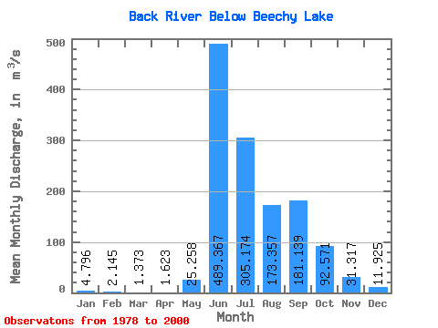
| Statistic | Jan | Feb | Mar | Apr | May | Jun | Jul | Aug | Sep | Oct | Nov | Dec | Annual |
|---|---|---|---|---|---|---|---|---|---|---|---|---|---|
| Mean | 4.80 | 2.15 | 1.37 | 1.62 | 25.26 | 489.37 | 305.17 | 173.36 | 181.14 | 92.57 | 31.32 | 11.93 | 108.82 |
| Standard Deviation | 5.41 | 2.98 | 1.91 | 1.59 | 30.57 | 243.05 | 92.43 | 49.13 | 106.20 | 36.68 | 20.47 | 10.03 | 30.66 |
| Min | 0.00 | 0.00 | 0.00 | 0.00 | 0.00 | 92.70 | 106.00 | 82.90 | 87.00 | 33.70 | 6.56 | 0.19 | 55.65 |
| Max | 17.10 | 8.45 | 4.80 | 4.14 | 92.50 | 1180.00 | 434.00 | 266.00 | 556.00 | 153.00 | 72.20 | 26.50 | 177.75 |
| Coefficient of Variation | 1.13 | 1.39 | 1.39 | 0.98 | 1.21 | 0.50 | 0.30 | 0.28 | 0.59 | 0.40 | 0.65 | 0.84 | 0.28 |
 Return to R-Arctic Net Home Page