|
|
|||||||||||||||||
| Point ID: 3675 | Downloads | Plots | Site Data | Code: 10PB001 |
|
|
|||||||||||||||||
| Download | |
|---|---|
| Site Descriptor Information | Site Time Series Data |
| Link to all available data | |
| View: | Time Series | All |
| Units: | m3/s |
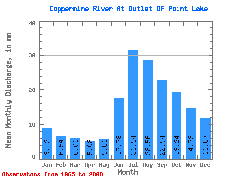
| Statistic | Jan | Feb | Mar | Apr | May | Jun | Jul | Aug | Sep | Oct | Nov | Dec | Annual |
|---|---|---|---|---|---|---|---|---|---|---|---|---|---|
| Mean | 9.12 | 6.60 | 6.00 | 5.08 | 5.81 | 17.73 | 31.54 | 28.56 | 22.93 | 19.24 | 14.73 | 11.87 | 176.99 |
| Standard Deviation | 2.13 | 1.42 | 1.21 | 0.91 | 1.24 | 6.32 | 10.67 | 7.62 | 7.92 | 6.83 | 4.49 | 3.09 | 42.00 |
| Min | 4.98 | 3.77 | 3.57 | 3.12 | 3.40 | 8.77 | 16.37 | 14.15 | 10.78 | 9.14 | 7.64 | 6.42 | 105.81 |
| Max | 14.29 | 9.51 | 8.55 | 7.02 | 8.67 | 35.86 | 66.05 | 50.65 | 58.42 | 48.29 | 29.28 | 20.40 | 291.63 |
| Coefficient of Variation | 0.23 | 0.21 | 0.20 | 0.18 | 0.21 | 0.36 | 0.34 | 0.27 | 0.34 | 0.35 | 0.30 | 0.26 | 0.24 |
 Return to R-Arctic Net Home Page