|
|
|||||||||||||||||
| Point ID: 3675 | Downloads | Plots | Site Data | Code: 10PB001 |
|
|
|||||||||||||||||
| Download | |
|---|---|
| Site Descriptor Information | Site Time Series Data |
| Link to all available data | |
| View: | Time Series | All |
| Units: | mm |
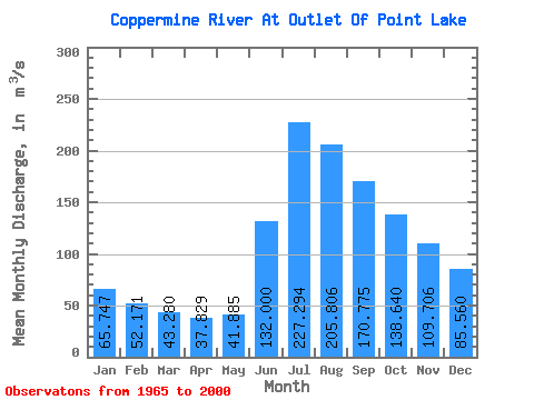
| Statistic | Jan | Feb | Mar | Apr | May | Jun | Jul | Aug | Sep | Oct | Nov | Dec | Annual |
|---|---|---|---|---|---|---|---|---|---|---|---|---|---|
| Mean | 65.75 | 52.17 | 43.28 | 37.83 | 41.88 | 132.00 | 227.29 | 205.81 | 170.78 | 138.64 | 109.71 | 85.56 | 108.23 |
| Standard Deviation | 15.37 | 11.20 | 8.73 | 6.80 | 8.95 | 47.05 | 76.87 | 54.92 | 58.96 | 49.21 | 33.42 | 22.29 | 25.68 |
| Min | 35.90 | 29.80 | 25.70 | 23.20 | 24.50 | 65.30 | 118.00 | 102.00 | 80.30 | 65.90 | 56.90 | 46.30 | 64.71 |
| Max | 103.00 | 75.20 | 61.60 | 52.30 | 62.50 | 267.00 | 476.00 | 365.00 | 435.00 | 348.00 | 218.00 | 147.00 | 178.34 |
| Coefficient of Variation | 0.23 | 0.21 | 0.20 | 0.18 | 0.21 | 0.36 | 0.34 | 0.27 | 0.34 | 0.35 | 0.30 | 0.26 | 0.24 |
 Return to R-Arctic Net Home Page