|
|
|||||||||||||||||
| Point ID: 3667 | Downloads | Plots | Site Data | Code: 10NA001 |
|
|
|||||||||||||||||
| Download | |
|---|---|
| Site Descriptor Information | Site Time Series Data |
| Link to all available data | |
| View: | Time Series | All |
| Units: | m3/s |
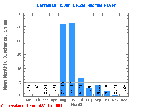
| Statistic | Jan | Feb | Mar | Apr | May | Jun | Jul | Aug | Sep | Oct | Nov | Dec | Annual |
|---|---|---|---|---|---|---|---|---|---|---|---|---|---|
| Mean | 0.07 | 0.02 | 0.01 | 0.01 | 26.10 | 26.17 | 6.71 | 2.96 | 4.13 | 2.15 | 0.71 | 0.24 | 68.94 |
| Standard Deviation | 0.08 | 0.03 | 0.02 | 0.01 | 17.81 | 10.68 | 3.34 | 1.63 | 4.16 | 1.71 | 0.52 | 0.19 | 27.93 |
| Min | 0.00 | 0.00 | 0.00 | 0.00 | 4.21 | 9.57 | 2.48 | 0.98 | 0.71 | 0.33 | 0.07 | 0.00 | 20.43 |
| Max | 0.24 | 0.11 | 0.06 | 0.05 | 68.51 | 46.29 | 14.95 | 6.30 | 14.11 | 4.79 | 1.48 | 0.57 | 124.24 |
| Coefficient of Variation | 1.21 | 1.98 | 2.62 | 2.51 | 0.68 | 0.41 | 0.50 | 0.55 | 1.01 | 0.80 | 0.73 | 0.82 | 0.41 |
 Return to R-Arctic Net Home Page