|
|
|||||||||||||||||
| Point ID: 3667 | Downloads | Plots | Site Data | Code: 10NA001 |
|
|
|||||||||||||||||
| Download | |
|---|---|
| Site Descriptor Information | Site Time Series Data |
| Link to all available data | |
| View: | Time Series | All |
| Units: | mm |
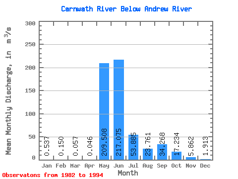
| Statistic | Jan | Feb | Mar | Apr | May | Jun | Jul | Aug | Sep | Oct | Nov | Dec | Annual |
|---|---|---|---|---|---|---|---|---|---|---|---|---|---|
| Mean | 0.54 | 0.15 | 0.06 | 0.05 | 209.51 | 217.07 | 53.88 | 23.76 | 34.27 | 17.23 | 5.86 | 1.91 | 46.96 |
| Standard Deviation | 0.65 | 0.30 | 0.15 | 0.12 | 142.96 | 88.59 | 26.86 | 13.07 | 34.53 | 13.73 | 4.29 | 1.56 | 19.03 |
| Min | 0.00 | 0.00 | 0.00 | 0.00 | 33.80 | 79.40 | 19.90 | 7.89 | 5.88 | 2.66 | 0.60 | 0.00 | 13.92 |
| Max | 1.94 | 0.96 | 0.51 | 0.40 | 550.00 | 384.00 | 120.00 | 50.60 | 117.00 | 38.50 | 12.30 | 4.55 | 84.64 |
| Coefficient of Variation | 1.21 | 1.98 | 2.62 | 2.51 | 0.68 | 0.41 | 0.50 | 0.55 | 1.01 | 0.80 | 0.73 | 0.82 | 0.41 |
 Return to R-Arctic Net Home Page