|
|
|||||||||||||||||
| Point ID: 3648 | Downloads | Plots | Site Data | Code: 10KC001 |
|
|
|||||||||||||||||
| Download | |
|---|---|
| Site Descriptor Information | Site Time Series Data |
| Link to all available data | |
| View: | Time Series | All |
| Units: | m3/s |
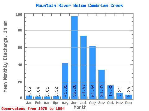
| Statistic | Jan | Feb | Mar | Apr | May | Jun | Jul | Aug | Sep | Oct | Nov | Dec | Annual |
|---|---|---|---|---|---|---|---|---|---|---|---|---|---|
| Mean | 4.06 | 3.06 | 3.01 | 3.32 | 41.91 | 96.28 | 73.66 | 61.63 | 34.39 | 15.82 | 7.21 | 5.36 | 348.34 |
| Standard Deviation | 0.75 | 0.68 | 0.73 | 0.93 | 13.86 | 20.04 | 18.94 | 19.92 | 10.61 | 3.75 | 1.07 | 0.79 | 41.80 |
| Min | 2.77 | 2.12 | 2.09 | 2.11 | 21.33 | 62.12 | 41.26 | 39.81 | 19.64 | 9.70 | 5.65 | 4.00 | 293.75 |
| Max | 5.04 | 4.09 | 4.42 | 5.32 | 66.35 | 134.27 | 101.09 | 105.91 | 56.28 | 24.05 | 9.27 | 6.75 | 464.37 |
| Coefficient of Variation | 0.18 | 0.22 | 0.24 | 0.28 | 0.33 | 0.21 | 0.26 | 0.32 | 0.31 | 0.24 | 0.15 | 0.15 | 0.12 |
 Return to R-Arctic Net Home Page