|
|
|||||||||||||||||
| Point ID: 3648 | Downloads | Plots | Site Data | Code: 10KC001 |
|
|
|||||||||||||||||
| Download | |
|---|---|
| Site Descriptor Information | Site Time Series Data |
| Link to all available data | |
| View: | Time Series | All |
| Units: | mm |
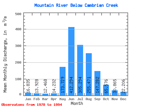
| Statistic | Jan | Feb | Mar | Apr | May | Jun | Jul | Aug | Sep | Oct | Nov | Dec | Annual |
|---|---|---|---|---|---|---|---|---|---|---|---|---|---|
| Mean | 16.84 | 13.93 | 12.47 | 14.23 | 173.73 | 412.29 | 305.29 | 255.47 | 147.28 | 65.58 | 30.86 | 22.21 | 122.52 |
| Standard Deviation | 3.10 | 3.09 | 3.04 | 3.99 | 57.47 | 85.80 | 78.49 | 82.57 | 45.45 | 15.53 | 4.56 | 3.25 | 14.70 |
| Min | 11.50 | 9.66 | 8.66 | 9.03 | 88.40 | 266.00 | 171.00 | 165.00 | 84.10 | 40.20 | 24.20 | 16.60 | 103.31 |
| Max | 20.90 | 18.60 | 18.30 | 22.80 | 275.00 | 575.00 | 419.00 | 439.00 | 241.00 | 99.70 | 39.70 | 28.00 | 163.32 |
| Coefficient of Variation | 0.18 | 0.22 | 0.24 | 0.28 | 0.33 | 0.21 | 0.26 | 0.32 | 0.31 | 0.24 | 0.15 | 0.15 | 0.12 |
 Return to R-Arctic Net Home Page