|
|
|||||||||||||||||
| Point ID: 3647 | Downloads | Plots | Site Data | Code: 10KB001 |
|
|
|||||||||||||||||
| Download | |
|---|---|
| Site Descriptor Information | Site Time Series Data |
| Link to all available data | |
| View: | Time Series | All |
| Units: | m3/s |
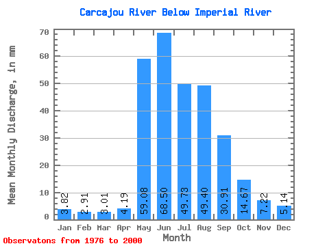
| Statistic | Jan | Feb | Mar | Apr | May | Jun | Jul | Aug | Sep | Oct | Nov | Dec | Annual |
|---|---|---|---|---|---|---|---|---|---|---|---|---|---|
| Mean | 3.82 | 2.94 | 3.01 | 4.20 | 59.07 | 68.50 | 49.72 | 49.39 | 30.91 | 14.67 | 7.22 | 5.14 | 296.98 |
| Standard Deviation | 0.91 | 0.87 | 0.89 | 1.84 | 21.07 | 30.36 | 21.43 | 23.83 | 11.20 | 4.43 | 1.40 | 0.97 | 74.54 |
| Min | 2.39 | 1.89 | 1.73 | 2.13 | 29.24 | 16.32 | 17.30 | 20.45 | 13.55 | 7.82 | 4.94 | 3.55 | 162.45 |
| Max | 5.61 | 4.68 | 4.49 | 10.33 | 108.93 | 118.39 | 96.26 | 106.76 | 58.15 | 22.26 | 9.63 | 6.51 | 403.09 |
| Coefficient of Variation | 0.24 | 0.29 | 0.30 | 0.44 | 0.36 | 0.44 | 0.43 | 0.48 | 0.36 | 0.30 | 0.19 | 0.19 | 0.25 |
 Return to R-Arctic Net Home Page