|
|
|||||||||||||||||
| Point ID: 3647 | Downloads | Plots | Site Data | Code: 10KB001 |
|
|
|||||||||||||||||
| Download | |
|---|---|
| Site Descriptor Information | Site Time Series Data |
| Link to all available data | |
| View: | Time Series | All |
| Units: | mm |
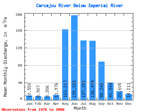
| Statistic | Jan | Feb | Mar | Apr | May | Jun | Jul | Aug | Sep | Oct | Nov | Dec | Annual |
|---|---|---|---|---|---|---|---|---|---|---|---|---|---|
| Mean | 10.55 | 8.91 | 8.31 | 11.98 | 163.22 | 195.56 | 137.39 | 136.47 | 88.24 | 40.54 | 20.61 | 14.21 | 69.63 |
| Standard Deviation | 2.52 | 2.63 | 2.46 | 5.24 | 58.21 | 86.67 | 59.22 | 65.85 | 31.97 | 12.24 | 3.98 | 2.68 | 17.48 |
| Min | 6.60 | 5.72 | 4.79 | 6.07 | 80.80 | 46.60 | 47.80 | 56.50 | 38.70 | 21.60 | 14.10 | 9.81 | 38.09 |
| Max | 15.50 | 14.20 | 12.40 | 29.50 | 301.00 | 338.00 | 266.00 | 295.00 | 166.00 | 61.50 | 27.50 | 18.00 | 94.52 |
| Coefficient of Variation | 0.24 | 0.29 | 0.30 | 0.44 | 0.36 | 0.44 | 0.43 | 0.48 | 0.36 | 0.30 | 0.19 | 0.19 | 0.25 |
 Return to R-Arctic Net Home Page