|
|
|||||||||||||||||
| Point ID: 3638 | Downloads | Plots | Site Data | Code: 10JC003 |
|
|
|||||||||||||||||
| Download | |
|---|---|
| Site Descriptor Information | Site Time Series Data |
| Link to all available data | |
| View: | Time Series | All |
| Units: | m3/s |
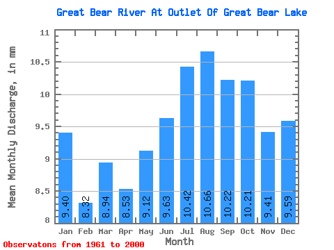
| Statistic | Jan | Feb | Mar | Apr | May | Jun | Jul | Aug | Sep | Oct | Nov | Dec | Annual |
|---|---|---|---|---|---|---|---|---|---|---|---|---|---|
| Mean | 9.40 | 8.39 | 8.94 | 8.54 | 9.12 | 9.63 | 10.42 | 10.66 | 10.22 | 10.20 | 9.41 | 9.59 | 115.46 |
| Standard Deviation | 0.78 | 0.77 | 0.85 | 0.72 | 0.77 | 0.94 | 1.15 | 1.24 | 1.14 | 1.01 | 0.97 | 0.99 | 9.11 |
| Min | 7.83 | 7.07 | 7.33 | 6.99 | 7.52 | 8.12 | 8.87 | 8.85 | 8.51 | 8.53 | 8.12 | 7.83 | 99.43 |
| Max | 11.03 | 10.10 | 10.18 | 9.65 | 10.66 | 12.35 | 13.37 | 13.83 | 13.32 | 12.69 | 11.53 | 11.95 | 129.60 |
| Coefficient of Variation | 0.08 | 0.09 | 0.10 | 0.09 | 0.08 | 0.10 | 0.11 | 0.12 | 0.11 | 0.10 | 0.10 | 0.10 | 0.08 |
 Return to R-Arctic Net Home Page