|
|
|||||||||||||||||
| Point ID: 3638 | Downloads | Plots | Site Data | Code: 10JC003 |
|
|
|||||||||||||||||
| Download | |
|---|---|
| Site Descriptor Information | Site Time Series Data |
| Link to all available data | |
| View: | Time Series | All |
| Units: | mm |
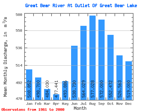
| Statistic | Jan | Feb | Mar | Apr | May | Jun | Jul | Aug | Sep | Oct | Nov | Dec | Annual |
|---|---|---|---|---|---|---|---|---|---|---|---|---|---|
| Mean | 508.85 | 498.70 | 484.03 | 477.44 | 493.89 | 538.73 | 564.03 | 577.03 | 572.00 | 552.47 | 526.56 | 519.00 | 530.48 |
| Standard Deviation | 42.46 | 45.44 | 45.87 | 40.58 | 41.47 | 52.65 | 62.12 | 67.02 | 63.72 | 54.86 | 54.55 | 53.72 | 41.83 |
| Min | 424.00 | 420.00 | 397.00 | 391.00 | 407.00 | 454.00 | 480.00 | 479.00 | 476.00 | 462.00 | 454.00 | 424.00 | 456.83 |
| Max | 597.00 | 600.00 | 551.00 | 540.00 | 577.00 | 691.00 | 724.00 | 749.00 | 745.00 | 687.00 | 645.00 | 647.00 | 595.42 |
| Coefficient of Variation | 0.08 | 0.09 | 0.10 | 0.09 | 0.08 | 0.10 | 0.11 | 0.12 | 0.11 | 0.10 | 0.10 | 0.10 | 0.08 |
 Return to R-Arctic Net Home Page