|
|
|||||||||||||||||
| Point ID: 3634 | Downloads | Plots | Site Data | Code: 10HC006 |
|
|
|||||||||||||||||
| Download | |
|---|---|
| Site Descriptor Information | Site Time Series Data |
| Link to all available data | |
| View: | Time Series | All |
| Units: | m3/s |
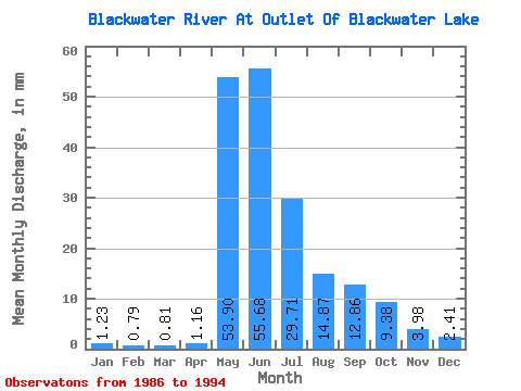
| Statistic | Jan | Feb | Mar | Apr | May | Jun | Jul | Aug | Sep | Oct | Nov | Dec | Annual |
|---|---|---|---|---|---|---|---|---|---|---|---|---|---|
| Mean | 1.23 | 0.80 | 0.81 | 1.16 | 53.89 | 55.69 | 29.71 | 14.87 | 12.86 | 9.38 | 3.98 | 2.41 | 185.31 |
| Standard Deviation | 0.79 | 0.53 | 0.50 | 0.77 | 24.64 | 28.44 | 28.46 | 8.58 | 13.39 | 8.06 | 2.65 | 1.57 | 65.18 |
| Min | 0.04 | 0.00 | 0.02 | 0.04 | 28.79 | 22.98 | 10.85 | 4.81 | 2.29 | 2.35 | 1.11 | 0.58 | 86.16 |
| Max | 2.27 | 1.48 | 1.47 | 2.79 | 92.11 | 113.59 | 102.34 | 26.00 | 40.94 | 24.63 | 7.56 | 5.08 | 280.69 |
| Coefficient of Variation | 0.64 | 0.66 | 0.61 | 0.67 | 0.46 | 0.51 | 0.96 | 0.58 | 1.04 | 0.86 | 0.67 | 0.65 | 0.35 |
 Return to R-Arctic Net Home Page