|
|
|||||||||||||||||
| Point ID: 3634 | Downloads | Plots | Site Data | Code: 10HC006 |
|
|
|||||||||||||||||
| Download | |
|---|---|
| Site Descriptor Information | Site Time Series Data |
| Link to all available data | |
| View: | Time Series | All |
| Units: | mm |
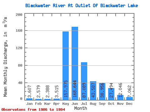
| Statistic | Jan | Feb | Mar | Apr | May | Jun | Jul | Aug | Sep | Oct | Nov | Dec | Annual |
|---|---|---|---|---|---|---|---|---|---|---|---|---|---|
| Mean | 3.61 | 2.58 | 2.39 | 3.52 | 157.97 | 168.64 | 87.09 | 43.59 | 38.96 | 27.49 | 12.05 | 7.06 | 46.09 |
| Standard Deviation | 2.32 | 1.69 | 1.47 | 2.34 | 72.23 | 86.14 | 83.41 | 25.15 | 40.56 | 23.64 | 8.02 | 4.61 | 16.21 |
| Min | 0.11 | 0.01 | 0.05 | 0.12 | 84.40 | 69.60 | 31.80 | 14.10 | 6.95 | 6.89 | 3.35 | 1.70 | 21.43 |
| Max | 6.64 | 4.76 | 4.30 | 8.46 | 270.00 | 344.00 | 300.00 | 76.20 | 124.00 | 72.20 | 22.90 | 14.90 | 69.82 |
| Coefficient of Variation | 0.64 | 0.66 | 0.61 | 0.67 | 0.46 | 0.51 | 0.96 | 0.58 | 1.04 | 0.86 | 0.67 | 0.65 | 0.35 |
 Return to R-Arctic Net Home Page