|
|
|||||||||||||||||
| Point ID: 3631 | Downloads | Plots | Site Data | Code: 10HB005 |
|
|
|||||||||||||||||
| Download | |
|---|---|
| Site Descriptor Information | Site Time Series Data |
| Link to all available data | |
| View: | Time Series | All |
| Units: | m3/s |
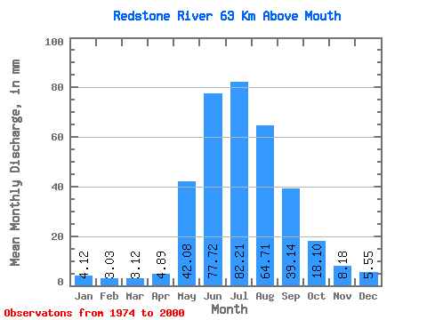
| Statistic | Jan | Feb | Mar | Apr | May | Jun | Jul | Aug | Sep | Oct | Nov | Dec | Annual |
|---|---|---|---|---|---|---|---|---|---|---|---|---|---|
| Mean | 4.12 | 3.05 | 3.12 | 4.89 | 42.07 | 77.72 | 82.20 | 64.70 | 39.14 | 18.09 | 8.18 | 5.55 | 357.10 |
| Standard Deviation | 1.13 | 0.82 | 0.84 | 2.22 | 13.86 | 24.89 | 31.55 | 19.76 | 14.39 | 3.92 | 2.09 | 1.26 | 81.33 |
| Min | 1.90 | 1.69 | 1.83 | 2.05 | 15.96 | 30.46 | 38.78 | 31.48 | 18.68 | 12.45 | 5.20 | 3.11 | 224.03 |
| Max | 7.03 | 4.64 | 4.52 | 9.91 | 63.82 | 118.32 | 156.33 | 99.99 | 70.69 | 25.21 | 13.14 | 8.62 | 447.68 |
| Coefficient of Variation | 0.28 | 0.27 | 0.27 | 0.45 | 0.33 | 0.32 | 0.38 | 0.30 | 0.37 | 0.22 | 0.26 | 0.23 | 0.23 |
 Return to R-Arctic Net Home Page