|
|
|||||||||||||||||
| Point ID: 3631 | Downloads | Plots | Site Data | Code: 10HB005 |
|
|
|||||||||||||||||
| Download | |
|---|---|
| Site Descriptor Information | Site Time Series Data |
| Link to all available data | |
| View: | Time Series | All |
| Units: | mm |
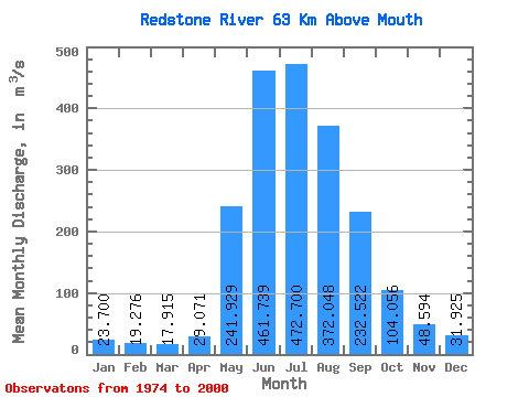
| Statistic | Jan | Feb | Mar | Apr | May | Jun | Jul | Aug | Sep | Oct | Nov | Dec | Annual |
|---|---|---|---|---|---|---|---|---|---|---|---|---|---|
| Mean | 23.70 | 19.28 | 17.91 | 29.07 | 241.93 | 461.74 | 472.70 | 372.05 | 232.52 | 104.06 | 48.59 | 31.93 | 174.25 |
| Standard Deviation | 6.52 | 5.15 | 4.84 | 13.18 | 79.72 | 147.86 | 181.41 | 113.65 | 85.49 | 22.52 | 12.41 | 7.25 | 39.68 |
| Min | 10.90 | 10.70 | 10.50 | 12.20 | 91.80 | 181.00 | 223.00 | 181.00 | 111.00 | 71.60 | 30.90 | 17.90 | 109.32 |
| Max | 40.40 | 29.30 | 26.00 | 58.90 | 367.00 | 703.00 | 899.00 | 575.00 | 420.00 | 145.00 | 78.10 | 49.60 | 218.45 |
| Coefficient of Variation | 0.28 | 0.27 | 0.27 | 0.45 | 0.33 | 0.32 | 0.38 | 0.30 | 0.37 | 0.22 | 0.26 | 0.23 | 0.23 |
 Return to R-Arctic Net Home Page