|
|
|||||||||||||||||
| Point ID: 3613 | Downloads | Plots | Site Data | Code: 10FA002 |
|
|
|||||||||||||||||
| Download | |
|---|---|
| Site Descriptor Information | Site Time Series Data |
| Link to all available data | |
| View: | Time Series | All |
| Units: | m3/s |
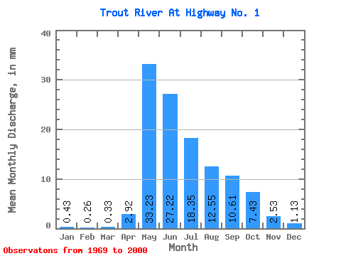
| Statistic | Jan | Feb | Mar | Apr | May | Jun | Jul | Aug | Sep | Oct | Nov | Dec | Annual |
|---|---|---|---|---|---|---|---|---|---|---|---|---|---|
| Mean | 0.43 | 0.26 | 0.33 | 2.92 | 33.22 | 27.22 | 18.35 | 12.55 | 10.61 | 7.43 | 2.53 | 1.13 | 116.88 |
| Standard Deviation | 0.49 | 0.28 | 0.42 | 2.99 | 16.29 | 13.67 | 14.47 | 8.46 | 8.90 | 5.35 | 2.48 | 1.42 | 47.13 |
| Min | 0.01 | 0.00 | 0.00 | 0.03 | 6.30 | 5.96 | 4.04 | 2.33 | 1.28 | 0.56 | 0.11 | 0.03 | 29.54 |
| Max | 2.40 | 1.04 | 1.72 | 10.82 | 62.98 | 53.41 | 82.62 | 37.56 | 32.72 | 19.56 | 9.79 | 7.05 | 232.38 |
| Coefficient of Variation | 1.13 | 1.07 | 1.26 | 1.02 | 0.49 | 0.50 | 0.79 | 0.67 | 0.84 | 0.72 | 0.98 | 1.25 | 0.40 |
 Return to R-Arctic Net Home Page