|
|
|||||||||||||||||
| Point ID: 3613 | Downloads | Plots | Site Data | Code: 10FA002 |
|
|
|||||||||||||||||
| Download | |
|---|---|
| Site Descriptor Information | Site Time Series Data |
| Link to all available data | |
| View: | Time Series | All |
| Units: | mm |
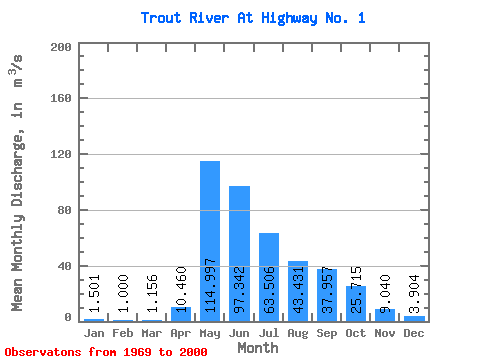
| Statistic | Jan | Feb | Mar | Apr | May | Jun | Jul | Aug | Sep | Oct | Nov | Dec | Annual |
|---|---|---|---|---|---|---|---|---|---|---|---|---|---|
| Mean | 1.50 | 1.00 | 1.16 | 10.46 | 115.00 | 97.34 | 63.51 | 43.43 | 37.96 | 25.71 | 9.04 | 3.90 | 34.33 |
| Standard Deviation | 1.70 | 1.07 | 1.46 | 10.69 | 56.39 | 48.90 | 50.10 | 29.29 | 31.84 | 18.52 | 8.88 | 4.90 | 13.84 |
| Min | 0.04 | 0.01 | 0.00 | 0.10 | 21.80 | 21.30 | 14.00 | 8.05 | 4.59 | 1.95 | 0.39 | 0.11 | 8.68 |
| Max | 8.31 | 3.95 | 5.94 | 38.70 | 218.00 | 191.00 | 286.00 | 130.00 | 117.00 | 67.70 | 35.00 | 24.40 | 68.26 |
| Coefficient of Variation | 1.13 | 1.07 | 1.26 | 1.02 | 0.49 | 0.50 | 0.79 | 0.67 | 0.84 | 0.72 | 0.98 | 1.25 | 0.40 |
 Return to R-Arctic Net Home Page