|
|
|||||||||||||||||
| Point ID: 3568 | Downloads | Plots | Site Data | Code: 07QC003 |
|
|
|||||||||||||||||
| Download | |
|---|---|
| Site Descriptor Information | Site Time Series Data |
| Link to all available data | |
| View: | Time Series | All |
| Units: | m3/s |
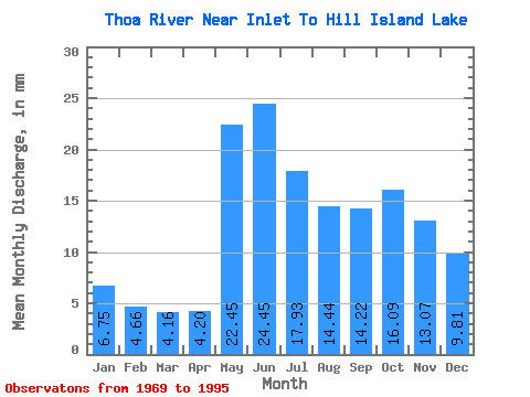
| Statistic | Jan | Feb | Mar | Apr | May | Jun | Jul | Aug | Sep | Oct | Nov | Dec | Annual |
|---|---|---|---|---|---|---|---|---|---|---|---|---|---|
| Mean | 6.75 | 4.70 | 4.16 | 4.20 | 22.45 | 24.45 | 17.92 | 14.43 | 14.22 | 16.09 | 13.07 | 9.81 | 154.86 |
| Standard Deviation | 2.43 | 1.62 | 1.41 | 1.69 | 11.26 | 11.72 | 6.67 | 7.32 | 7.27 | 9.14 | 5.79 | 3.66 | 49.34 |
| Min | 2.70 | 1.94 | 1.82 | 1.83 | 9.73 | 9.80 | 7.52 | 4.97 | 4.08 | 4.25 | 3.61 | 3.09 | 81.49 |
| Max | 13.10 | 8.79 | 7.67 | 8.60 | 44.28 | 55.77 | 35.18 | 35.79 | 27.59 | 47.01 | 31.41 | 18.59 | 277.80 |
| Coefficient of Variation | 0.36 | 0.34 | 0.34 | 0.40 | 0.50 | 0.48 | 0.37 | 0.51 | 0.51 | 0.57 | 0.44 | 0.37 | 0.32 |
 Return to R-Arctic Net Home Page