|
|
|||||||||||||||||
| Point ID: 3568 | Downloads | Plots | Site Data | Code: 07QC003 |
|
|
|||||||||||||||||
| Download | |
|---|---|
| Site Descriptor Information | Site Time Series Data |
| Link to all available data | |
| View: | Time Series | All |
| Units: | mm |
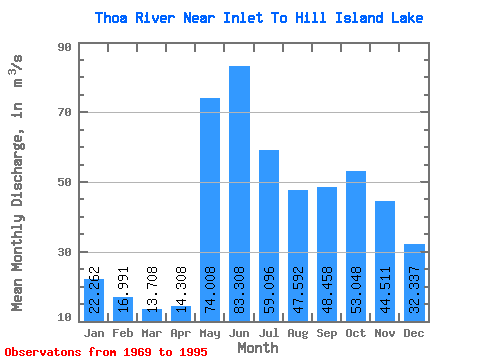
| Statistic | Jan | Feb | Mar | Apr | May | Jun | Jul | Aug | Sep | Oct | Nov | Dec | Annual |
|---|---|---|---|---|---|---|---|---|---|---|---|---|---|
| Mean | 22.26 | 16.99 | 13.71 | 14.31 | 74.01 | 83.31 | 59.10 | 47.59 | 48.46 | 53.05 | 44.51 | 32.34 | 43.33 |
| Standard Deviation | 8.02 | 5.85 | 4.64 | 5.75 | 37.14 | 39.93 | 22.01 | 24.14 | 24.77 | 30.13 | 19.71 | 12.08 | 13.80 |
| Min | 8.91 | 7.03 | 6.01 | 6.25 | 32.10 | 33.40 | 24.80 | 16.40 | 13.90 | 14.00 | 12.30 | 10.20 | 22.80 |
| Max | 43.20 | 31.80 | 25.30 | 29.30 | 146.00 | 190.00 | 116.00 | 118.00 | 94.00 | 155.00 | 107.00 | 61.30 | 77.72 |
| Coefficient of Variation | 0.36 | 0.34 | 0.34 | 0.40 | 0.50 | 0.48 | 0.37 | 0.51 | 0.51 | 0.57 | 0.44 | 0.37 | 0.32 |
 Return to R-Arctic Net Home Page