|
|
|||||||||||||||||
| Point ID: 3562 | Downloads | Plots | Site Data | Code: 07PA001 |
|
|
|||||||||||||||||
| Download | |
|---|---|
| Site Descriptor Information | Site Time Series Data |
| Link to all available data | |
| View: | Time Series | All |
| Units: | m3/s |
| Statistic | Jan | Feb | Mar | Apr | May | Jun | Jul | Aug | Sep | Oct | Nov | Dec | Annual |
|---|---|---|---|---|---|---|---|---|---|---|---|---|---|
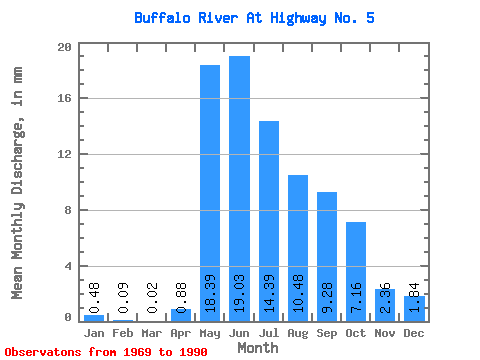
| Mean | 0.47 | 0.09 | 0.02 | 0.88 | 18.39 | 19.04 | 14.38 | 10.48 | 9.28 | 7.16 | 2.36 | 1.84 | 83.92 |
| Standard Deviation | 0.68 | 0.14 | 0.04 | 1.32 | 8.27 | 9.66 | 8.06 | 6.73 | 6.94 | 5.25 | 2.10 | 2.30 | 40.47 |
| Min | 0.00 | 0.00 | 0.00 | 0.01 | 6.07 | 3.98 | 2.16 | 1.55 | 0.80 | 1.11 | 0.03 | 0.00 | 20.95 |
| Max | 2.71 | 0.44 | 0.11 | 5.94 | 37.49 | 41.05 | 34.60 | 23.59 | 24.24 | 19.83 | 7.96 | 6.80 | 165.69 |
| Coefficient of Variation | 1.44 | 1.60 | 1.81 | 1.50 | 0.45 | 0.51 | 0.56 | 0.64 | 0.75 | 0.73 | 0.89 | 1.25 | 0.48 |
 Return to R-Arctic Net Home Page