|
|
|||||||||||||||||
| Point ID: 3562 | Downloads | Plots | Site Data | Code: 07PA001 |
|
|
|||||||||||||||||
| Download | |
|---|---|
| Site Descriptor Information | Site Time Series Data |
| Link to all available data | |
| View: | Time Series | All |
| Units: | mm |
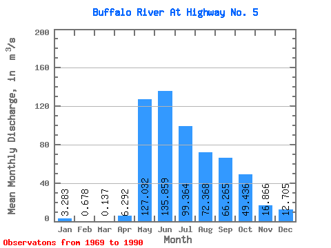
| Statistic | Jan | Feb | Mar | Apr | May | Jun | Jul | Aug | Sep | Oct | Nov | Dec | Annual |
|---|---|---|---|---|---|---|---|---|---|---|---|---|---|
| Mean | 3.28 | 0.68 | 0.14 | 6.29 | 127.03 | 135.86 | 99.36 | 72.37 | 66.27 | 49.44 | 16.87 | 12.71 | 49.19 |
| Standard Deviation | 4.71 | 1.09 | 0.25 | 9.46 | 57.12 | 68.98 | 55.66 | 46.48 | 49.51 | 36.27 | 14.96 | 15.91 | 23.72 |
| Min | 0.00 | 0.00 | 0.00 | 0.05 | 41.90 | 28.40 | 14.90 | 10.70 | 5.73 | 7.69 | 0.19 | 0.03 | 12.28 |
| Max | 18.70 | 3.37 | 0.78 | 42.40 | 259.00 | 293.00 | 239.00 | 163.00 | 173.00 | 137.00 | 56.80 | 47.00 | 97.12 |
| Coefficient of Variation | 1.44 | 1.60 | 1.81 | 1.50 | 0.45 | 0.51 | 0.56 | 0.64 | 0.75 | 0.73 | 0.89 | 1.25 | 0.48 |
 Return to R-Arctic Net Home Page