|
|
|||||||||||||||||
| Point ID: 3544 | Downloads | Plots | Site Data | Code: 06NB002 |
|
|
|||||||||||||||||
| Download | |
|---|---|
| Site Descriptor Information | Site Time Series Data |
| Link to all available data | |
| View: | Time Series | All |
| Units: | m3/s |
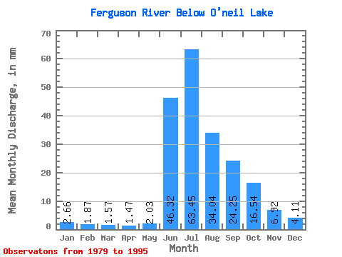
| Statistic | Jan | Feb | Mar | Apr | May | Jun | Jul | Aug | Sep | Oct | Nov | Dec | Annual |
|---|---|---|---|---|---|---|---|---|---|---|---|---|---|
| Mean | 2.66 | 1.89 | 1.57 | 1.47 | 2.03 | 46.32 | 63.44 | 34.03 | 24.25 | 16.54 | 6.92 | 4.11 | 206.03 |
| Standard Deviation | 1.90 | 1.35 | 1.40 | 1.45 | 2.13 | 20.92 | 22.53 | 6.24 | 5.53 | 5.45 | 3.08 | 2.31 | 44.49 |
| Min | 0.00 | 0.00 | 0.00 | 0.00 | 0.00 | 18.54 | 35.20 | 19.55 | 17.77 | 10.60 | 1.77 | 0.40 | 145.91 |
| Max | 6.26 | 4.01 | 3.80 | 3.66 | 5.75 | 102.64 | 121.59 | 48.59 | 37.63 | 29.37 | 14.74 | 9.83 | 288.88 |
| Coefficient of Variation | 0.72 | 0.71 | 0.90 | 0.98 | 1.04 | 0.45 | 0.35 | 0.18 | 0.23 | 0.33 | 0.45 | 0.56 | 0.22 |
 Return to R-Arctic Net Home Page