|
|
|||||||||||||||||
| Point ID: 3544 | Downloads | Plots | Site Data | Code: 06NB002 |
|
|
|||||||||||||||||
| Download | |
|---|---|
| Site Descriptor Information | Site Time Series Data |
| Link to all available data | |
| View: | Time Series | All |
| Units: | mm |
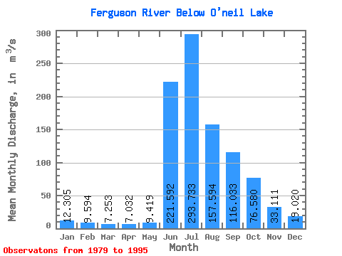
| Statistic | Jan | Feb | Mar | Apr | May | Jun | Jul | Aug | Sep | Oct | Nov | Dec | Annual |
|---|---|---|---|---|---|---|---|---|---|---|---|---|---|
| Mean | 12.30 | 9.59 | 7.25 | 7.03 | 9.42 | 221.59 | 293.73 | 157.59 | 116.03 | 76.58 | 33.11 | 19.02 | 80.95 |
| Standard Deviation | 8.81 | 6.86 | 6.49 | 6.92 | 9.84 | 100.10 | 104.30 | 28.89 | 26.43 | 25.22 | 14.76 | 10.68 | 17.48 |
| Min | 0.00 | 0.00 | 0.00 | 0.00 | 0.00 | 88.70 | 163.00 | 90.50 | 85.00 | 49.10 | 8.45 | 1.85 | 57.33 |
| Max | 29.00 | 20.40 | 17.60 | 17.50 | 26.60 | 491.00 | 563.00 | 225.00 | 180.00 | 136.00 | 70.50 | 45.50 | 113.50 |
| Coefficient of Variation | 0.72 | 0.71 | 0.90 | 0.98 | 1.04 | 0.45 | 0.35 | 0.18 | 0.23 | 0.33 | 0.45 | 0.56 | 0.22 |
 Return to R-Arctic Net Home Page