|
|
|||||||||||||||||
| Point ID: 3543 | Downloads | Plots | Site Data | Code: 06MB001 |
|
|
|||||||||||||||||
| Download | |
|---|---|
| Site Descriptor Information | Site Time Series Data |
| Link to all available data | |
| View: | Time Series | All |
| Units: | m3/s |
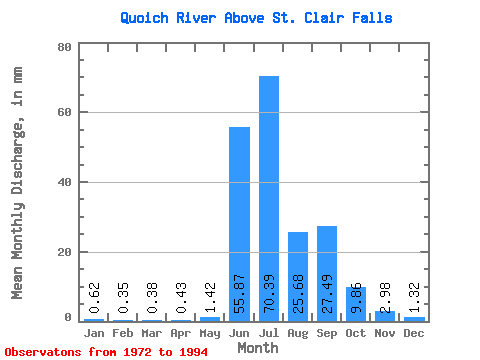
| Statistic | Jan | Feb | Mar | Apr | May | Jun | Jul | Aug | Sep | Oct | Nov | Dec | Annual |
|---|---|---|---|---|---|---|---|---|---|---|---|---|---|
| Mean | 0.62 | 0.35 | 0.38 | 0.42 | 1.42 | 55.87 | 70.38 | 25.67 | 27.49 | 9.86 | 2.98 | 1.32 | 195.67 |
| Standard Deviation | 0.36 | 0.18 | 0.23 | 0.21 | 1.78 | 32.60 | 38.33 | 11.37 | 11.82 | 5.06 | 1.27 | 0.59 | 47.72 |
| Min | 0.09 | 0.07 | 0.08 | 0.07 | 0.09 | 6.48 | 18.95 | 12.01 | 11.02 | 4.07 | 1.25 | 0.18 | 120.58 |
| Max | 1.43 | 0.60 | 1.04 | 0.85 | 7.01 | 107.64 | 166.37 | 46.17 | 52.96 | 21.98 | 6.62 | 2.54 | 288.01 |
| Coefficient of Variation | 0.58 | 0.50 | 0.60 | 0.50 | 1.26 | 0.58 | 0.55 | 0.44 | 0.43 | 0.51 | 0.42 | 0.45 | 0.24 |
 Return to R-Arctic Net Home Page