|
|
|||||||||||||||||
| Point ID: 3543 | Downloads | Plots | Site Data | Code: 06MB001 |
|
|
|||||||||||||||||
| Download | |
|---|---|
| Site Descriptor Information | Site Time Series Data |
| Link to all available data | |
| View: | Time Series | All |
| Units: | mm |
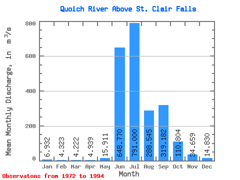
| Statistic | Jan | Feb | Mar | Apr | May | Jun | Jul | Aug | Sep | Oct | Nov | Dec | Annual |
|---|---|---|---|---|---|---|---|---|---|---|---|---|---|
| Mean | 6.93 | 4.32 | 4.22 | 4.94 | 15.91 | 648.77 | 791.00 | 288.55 | 319.18 | 110.80 | 34.66 | 14.83 | 186.62 |
| Standard Deviation | 4.05 | 2.17 | 2.56 | 2.47 | 20.05 | 378.60 | 430.84 | 127.79 | 137.22 | 56.85 | 14.71 | 6.59 | 45.51 |
| Min | 1.05 | 0.86 | 0.88 | 0.79 | 1.01 | 75.30 | 213.00 | 135.00 | 128.00 | 45.70 | 14.50 | 2.02 | 115.00 |
| Max | 16.10 | 7.41 | 11.70 | 9.82 | 78.80 | 1250.00 | 1870.00 | 519.00 | 615.00 | 247.00 | 76.90 | 28.50 | 274.69 |
| Coefficient of Variation | 0.58 | 0.50 | 0.60 | 0.50 | 1.26 | 0.58 | 0.55 | 0.44 | 0.43 | 0.51 | 0.42 | 0.45 | 0.24 |
 Return to R-Arctic Net Home Page