|
|
|||||||||||||||||
| Point ID: 3535 | Downloads | Plots | Site Data | Code: 06LC002 |
|
|
|||||||||||||||||
| Download | |
|---|---|
| Site Descriptor Information | Site Time Series Data |
| Link to all available data | |
| View: | Time Series | All |
| Units: | m3/s |
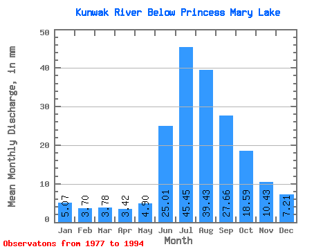
| Statistic | Jan | Feb | Mar | Apr | May | Jun | Jul | Aug | Sep | Oct | Nov | Dec | Annual |
|---|---|---|---|---|---|---|---|---|---|---|---|---|---|
| Mean | 5.07 | 3.73 | 3.78 | 3.42 | 4.90 | 25.01 | 45.45 | 39.43 | 27.66 | 18.59 | 10.43 | 7.21 | 193.70 |
| Standard Deviation | 2.05 | 1.59 | 1.75 | 1.62 | 2.51 | 8.04 | 11.96 | 9.75 | 5.63 | 4.36 | 3.50 | 2.50 | 36.72 |
| Min | 1.29 | 0.00 | 0.00 | 0.00 | 0.00 | 15.21 | 25.23 | 18.95 | 14.99 | 11.93 | 4.16 | 3.63 | 132.56 |
| Max | 8.30 | 5.97 | 6.86 | 6.15 | 10.89 | 38.99 | 66.62 | 59.31 | 39.20 | 26.56 | 15.85 | 11.09 | 271.30 |
| Coefficient of Variation | 0.40 | 0.43 | 0.46 | 0.47 | 0.51 | 0.32 | 0.26 | 0.25 | 0.20 | 0.23 | 0.34 | 0.35 | 0.19 |
 Return to R-Arctic Net Home Page