|
|
|||||||||||||||||
| Point ID: 3535 | Downloads | Plots | Site Data | Code: 06LC002 |
|
|
|||||||||||||||||
| Download | |
|---|---|
| Site Descriptor Information | Site Time Series Data |
| Link to all available data | |
| View: | Time Series | All |
| Units: | mm |
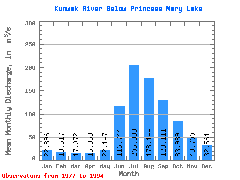
| Statistic | Jan | Feb | Mar | Apr | May | Jun | Jul | Aug | Sep | Oct | Nov | Dec | Annual |
|---|---|---|---|---|---|---|---|---|---|---|---|---|---|
| Mean | 22.90 | 18.52 | 17.07 | 15.95 | 22.15 | 116.74 | 205.33 | 178.14 | 129.11 | 83.99 | 48.70 | 32.56 | 74.26 |
| Standard Deviation | 9.25 | 7.88 | 7.89 | 7.58 | 11.32 | 37.54 | 54.02 | 44.04 | 26.30 | 19.68 | 16.33 | 11.29 | 14.08 |
| Min | 5.84 | 0.00 | 0.00 | 0.00 | 0.00 | 71.00 | 114.00 | 85.60 | 70.00 | 53.90 | 19.40 | 16.40 | 50.83 |
| Max | 37.50 | 29.60 | 31.00 | 28.70 | 49.20 | 182.00 | 301.00 | 268.00 | 183.00 | 120.00 | 74.00 | 50.10 | 104.02 |
| Coefficient of Variation | 0.40 | 0.43 | 0.46 | 0.47 | 0.51 | 0.32 | 0.26 | 0.25 | 0.20 | 0.23 | 0.34 | 0.35 | 0.19 |
 Return to R-Arctic Net Home Page