|
|
|||||||||||||||||
| Point ID: 3127 | Downloads | Plots | Site Data | Code: 06FA001 |
|
|
|||||||||||||||||
| Download | |
|---|---|
| Site Descriptor Information | Site Time Series Data |
| Link to all available data | |
| View: | Time Series | All |
| Units: | m3/s |
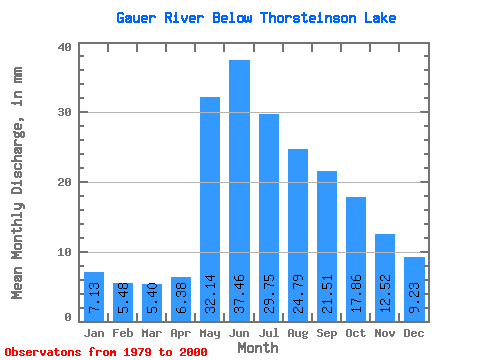
| Statistic | Jan | Feb | Mar | Apr | May | Jun | Jul | Aug | Sep | Oct | Nov | Dec | Annual |
|---|---|---|---|---|---|---|---|---|---|---|---|---|---|
| Mean | 7.13 | 5.53 | 5.40 | 6.38 | 32.14 | 37.46 | 29.74 | 24.78 | 21.51 | 17.85 | 12.52 | 9.22 | 204.73 |
| Standard Deviation | 2.83 | 1.98 | 1.75 | 3.23 | 15.28 | 13.13 | 12.33 | 13.67 | 16.82 | 12.02 | 7.81 | 4.90 | 62.67 |
| Min | 2.66 | 2.57 | 3.41 | 2.59 | 11.32 | 16.05 | 13.44 | 8.45 | 5.70 | 4.63 | 3.94 | 3.49 | 131.41 |
| Max | 12.94 | 10.81 | 11.23 | 17.05 | 63.80 | 69.15 | 69.20 | 52.57 | 69.15 | 47.18 | 32.44 | 21.84 | 323.43 |
| Coefficient of Variation | 0.40 | 0.36 | 0.33 | 0.51 | 0.47 | 0.35 | 0.41 | 0.55 | 0.78 | 0.67 | 0.62 | 0.53 | 0.31 |
 Return to R-Arctic Net Home Page