|
|
|||||||||||||||||
| Point ID: 3127 | Downloads | Plots | Site Data | Code: 06FA001 |
|
|
|||||||||||||||||
| Download | |
|---|---|
| Site Descriptor Information | Site Time Series Data |
| Link to all available data | |
| View: | Time Series | All |
| Units: | mm |
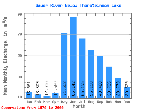
| Statistic | Jan | Feb | Mar | Apr | May | Jun | Jul | Aug | Sep | Oct | Nov | Dec | Annual |
|---|---|---|---|---|---|---|---|---|---|---|---|---|---|
| Mean | 15.86 | 13.51 | 12.01 | 14.66 | 71.52 | 86.14 | 66.19 | 55.16 | 49.47 | 39.73 | 28.78 | 20.53 | 38.66 |
| Standard Deviation | 6.30 | 4.85 | 3.90 | 7.43 | 34.00 | 30.18 | 27.45 | 30.42 | 38.67 | 26.76 | 17.96 | 10.91 | 11.84 |
| Min | 5.91 | 6.28 | 7.59 | 5.95 | 25.20 | 36.90 | 29.90 | 18.80 | 13.10 | 10.30 | 9.05 | 7.76 | 24.82 |
| Max | 28.80 | 26.40 | 25.00 | 39.20 | 142.00 | 159.00 | 154.00 | 117.00 | 159.00 | 105.00 | 74.60 | 48.60 | 61.08 |
| Coefficient of Variation | 0.40 | 0.36 | 0.33 | 0.51 | 0.47 | 0.35 | 0.41 | 0.55 | 0.78 | 0.67 | 0.62 | 0.53 | 0.31 |
 Return to R-Arctic Net Home Page