|
|
|||||||||||||||||
| Point ID: 3112 | Downloads | Plots | Site Data | Code: 05UE005 |
|
|
|||||||||||||||||
| Download | |
|---|---|
| Site Descriptor Information | Site Time Series Data |
| Link to all available data | |
| View: | Time Series | All |
| Units: | m3/s |
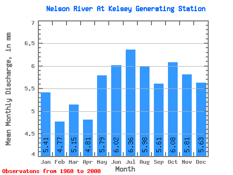
| Statistic | Jan | Feb | Mar | Apr | May | Jun | Jul | Aug | Sep | Oct | Nov | Dec | Annual |
|---|---|---|---|---|---|---|---|---|---|---|---|---|---|
| Mean | 5.41 | 4.81 | 5.14 | 4.81 | 5.79 | 6.01 | 6.36 | 5.98 | 5.61 | 6.08 | 5.81 | 5.63 | 67.30 |
| Standard Deviation | 1.09 | 1.00 | 1.15 | 1.27 | 2.06 | 2.82 | 2.99 | 2.55 | 2.10 | 1.69 | 1.10 | 1.06 | 16.91 |
| Min | 2.58 | 2.14 | 2.15 | 2.01 | 2.27 | 2.38 | 2.04 | 1.93 | 1.87 | 2.36 | 3.41 | 2.71 | 36.35 |
| Max | 7.13 | 6.52 | 6.89 | 6.83 | 9.44 | 11.29 | 12.73 | 12.01 | 10.42 | 9.73 | 8.16 | 7.66 | 102.34 |
| Coefficient of Variation | 0.20 | 0.21 | 0.22 | 0.26 | 0.36 | 0.47 | 0.47 | 0.43 | 0.37 | 0.28 | 0.19 | 0.19 | 0.25 |
 Return to R-Arctic Net Home Page