|
|
|||||||||||||||||
| Point ID: 3112 | Downloads | Plots | Site Data | Code: 05UE005 |
|
|
|||||||||||||||||
| Download | |
|---|---|
| Site Descriptor Information | Site Time Series Data |
| Link to all available data | |
| View: | Time Series | All |
| Units: | mm |
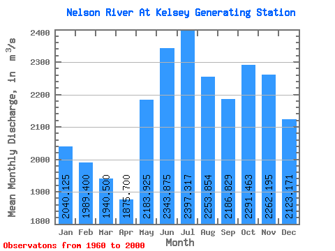
| Statistic | Jan | Feb | Mar | Apr | May | Jun | Jul | Aug | Sep | Oct | Nov | Dec | Annual |
|---|---|---|---|---|---|---|---|---|---|---|---|---|---|
| Mean | 2040.12 | 1989.40 | 1940.50 | 1875.70 | 2183.93 | 2343.88 | 2397.32 | 2253.85 | 2186.83 | 2291.46 | 2262.20 | 2123.17 | 2153.71 |
| Standard Deviation | 411.36 | 415.54 | 432.66 | 493.73 | 778.15 | 1100.26 | 1126.84 | 962.58 | 817.23 | 639.37 | 427.75 | 400.43 | 541.34 |
| Min | 975.00 | 886.00 | 810.00 | 783.00 | 857.00 | 929.00 | 771.00 | 727.00 | 730.00 | 890.00 | 1330.00 | 1020.00 | 1163.17 |
| Max | 2690.00 | 2700.00 | 2600.00 | 2660.00 | 3560.00 | 4400.00 | 4800.00 | 4530.00 | 4060.00 | 3670.00 | 3180.00 | 2890.00 | 3275.00 |
| Coefficient of Variation | 0.20 | 0.21 | 0.22 | 0.26 | 0.36 | 0.47 | 0.47 | 0.43 | 0.37 | 0.28 | 0.19 | 0.19 | 0.25 |
 Return to R-Arctic Net Home Page