|
|
|||||||||||||||||
| Point ID: 2993 | Downloads | Plots | Site Data | Code: 05OD001 |
|
|
|||||||||||||||||
| Download | |
|---|---|
| Site Descriptor Information | Site Time Series Data |
| Link to all available data | |
| View: | Time Series | All |
| Units: | m3/s |
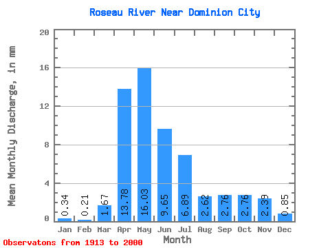
| Statistic | Jan | Feb | Mar | Apr | May | Jun | Jul | Aug | Sep | Oct | Nov | Dec | Annual |
|---|---|---|---|---|---|---|---|---|---|---|---|---|---|
| Mean | 0.34 | 0.21 | 1.67 | 13.78 | 16.03 | 9.65 | 6.89 | 2.62 | 2.76 | 2.76 | 2.39 | 0.85 | 61.79 |
| Standard Deviation | 0.32 | 0.17 | 3.03 | 9.52 | 15.35 | 9.16 | 7.56 | 4.34 | 4.58 | 3.92 | 2.65 | 0.97 | 39.30 |
| Min | 0.02 | 0.00 | 0.00 | 0.86 | 0.60 | 0.17 | 0.05 | 0.00 | 0.01 | 0.04 | 0.04 | 0.03 | 7.72 |
| Max | 1.98 | 0.99 | 16.14 | 45.73 | 72.81 | 40.01 | 29.58 | 24.08 | 23.16 | 21.28 | 12.02 | 6.01 | 166.48 |
| Coefficient of Variation | 0.95 | 0.82 | 1.82 | 0.69 | 0.96 | 0.95 | 1.10 | 1.66 | 1.66 | 1.42 | 1.11 | 1.13 | 0.64 |
 Return to R-Arctic Net Home Page