|
|
|||||||||||||||||
| Point ID: 2993 | Downloads | Plots | Site Data | Code: 05OD001 |
|
|
|||||||||||||||||
| Download | |
|---|---|
| Site Descriptor Information | Site Time Series Data |
| Link to all available data | |
| View: | Time Series | All |
| Units: | mm |
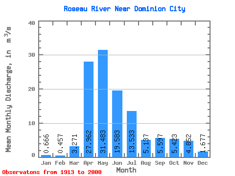
| Statistic | Jan | Feb | Mar | Apr | May | Jun | Jul | Aug | Sep | Oct | Nov | Dec | Annual |
|---|---|---|---|---|---|---|---|---|---|---|---|---|---|
| Mean | 0.67 | 0.46 | 3.27 | 27.96 | 31.48 | 19.58 | 13.53 | 5.14 | 5.60 | 5.42 | 4.85 | 1.68 | 10.30 |
| Standard Deviation | 0.63 | 0.38 | 5.95 | 19.31 | 30.15 | 18.59 | 14.85 | 8.53 | 9.30 | 7.70 | 5.37 | 1.90 | 6.55 |
| Min | 0.04 | 0.00 | 0.00 | 1.75 | 1.18 | 0.34 | 0.10 | 0.00 | 0.03 | 0.07 | 0.07 | 0.05 | 1.29 |
| Max | 3.88 | 2.13 | 31.70 | 92.80 | 143.00 | 81.20 | 58.10 | 47.30 | 47.00 | 41.80 | 24.40 | 11.80 | 27.75 |
| Coefficient of Variation | 0.95 | 0.82 | 1.82 | 0.69 | 0.96 | 0.95 | 1.10 | 1.66 | 1.66 | 1.42 | 1.11 | 1.13 | 0.64 |
 Return to R-Arctic Net Home Page