|
|
|||||||||||||||||
| Point ID: 2938 | Downloads | Plots | Site Data | Code: 05NG001 |
|
|
|||||||||||||||||
| Download | |
|---|---|
| Site Descriptor Information | Site Time Series Data |
| Link to all available data | |
| View: | Time Series | All |
| Units: | m3/s |
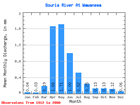
| Statistic | Jan | Feb | Mar | Apr | May | Jun | Jul | Aug | Sep | Oct | Nov | Dec | Annual |
|---|---|---|---|---|---|---|---|---|---|---|---|---|---|
| Mean | 0.04 | 0.04 | 0.18 | 1.66 | 1.71 | 1.00 | 0.52 | 0.25 | 0.13 | 0.13 | 0.12 | 0.06 | 6.54 |
| Standard Deviation | 0.07 | 0.05 | 0.27 | 2.65 | 2.43 | 1.59 | 0.76 | 0.34 | 0.17 | 0.18 | 0.16 | 0.09 | 8.59 |
| Min | 0.00 | 0.00 | 0.00 | 0.03 | 0.01 | 0.00 | 0.00 | 0.00 | 0.00 | 0.00 | 0.00 | 0.00 | 0.07 |
| Max | 0.40 | 0.30 | 1.10 | 20.70 | 12.54 | 8.27 | 3.79 | 1.71 | 1.16 | 1.18 | 1.06 | 0.54 | 42.29 |
| Coefficient of Variation | 1.68 | 1.50 | 1.47 | 1.60 | 1.42 | 1.59 | 1.45 | 1.35 | 1.30 | 1.39 | 1.40 | 1.51 | 1.31 |
 Return to R-Arctic Net Home Page