|
|
|||||||||||||||||
| Point ID: 2938 | Downloads | Plots | Site Data | Code: 05NG001 |
|
|
|||||||||||||||||
| Download | |
|---|---|
| Site Descriptor Information | Site Time Series Data |
| Link to all available data | |
| View: | Time Series | All |
| Units: | mm |
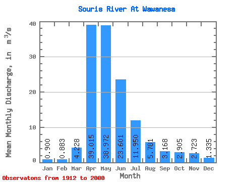
| Statistic | Jan | Feb | Mar | Apr | May | Jun | Jul | Aug | Sep | Oct | Nov | Dec | Annual |
|---|---|---|---|---|---|---|---|---|---|---|---|---|---|
| Mean | 0.90 | 0.88 | 4.23 | 39.02 | 38.97 | 23.60 | 11.95 | 5.78 | 3.17 | 2.91 | 2.72 | 1.33 | 12.66 |
| Standard Deviation | 1.52 | 1.33 | 6.20 | 62.40 | 55.38 | 37.44 | 17.37 | 7.83 | 4.14 | 4.05 | 3.80 | 2.01 | 16.63 |
| Min | 0.00 | 0.00 | 0.00 | 0.71 | 0.27 | 0.06 | 0.02 | 0.00 | 0.00 | 0.00 | 0.00 | 0.00 | 0.14 |
| Max | 9.01 | 7.47 | 25.20 | 488.00 | 286.00 | 195.00 | 86.50 | 39.10 | 27.30 | 26.80 | 24.90 | 12.20 | 81.87 |
| Coefficient of Variation | 1.68 | 1.50 | 1.47 | 1.60 | 1.42 | 1.59 | 1.45 | 1.35 | 1.30 | 1.39 | 1.40 | 1.51 | 1.31 |
 Return to R-Arctic Net Home Page