|
|
|||||||||||||||||
| Point ID: 2894 | Downloads | Plots | Site Data | Code: 05MF018 |
|
|
|||||||||||||||||
| Download | |
|---|---|
| Site Descriptor Information | Site Time Series Data |
| Link to all available data | |
| View: | Time Series | All |
| Units: | m3/s |
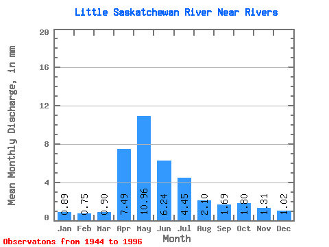
| Statistic | Jan | Feb | Mar | Apr | May | Jun | Jul | Aug | Sep | Oct | Nov | Dec | Annual |
|---|---|---|---|---|---|---|---|---|---|---|---|---|---|
| Mean | 0.89 | 0.76 | 0.90 | 7.49 | 10.96 | 6.24 | 4.45 | 2.10 | 1.69 | 1.80 | 1.31 | 1.02 | 36.62 |
| Standard Deviation | 0.60 | 0.49 | 0.80 | 6.56 | 8.82 | 5.67 | 5.59 | 2.08 | 2.44 | 2.40 | 1.22 | 0.73 | 24.49 |
| Min | 0.01 | 0.00 | 0.02 | 0.13 | 0.10 | 0.39 | 0.33 | 0.16 | 0.01 | 0.01 | 0.02 | 0.12 | 3.12 |
| Max | 2.77 | 2.25 | 4.83 | 31.69 | 37.67 | 28.97 | 29.59 | 9.18 | 15.78 | 15.89 | 5.83 | 2.98 | 112.99 |
| Coefficient of Variation | 0.68 | 0.65 | 0.89 | 0.88 | 0.81 | 0.91 | 1.26 | 0.99 | 1.45 | 1.33 | 0.93 | 0.71 | 0.67 |
 Return to R-Arctic Net Home Page