|
|
|||||||||||||||||
| Point ID: 2894 | Downloads | Plots | Site Data | Code: 05MF018 |
|
|
|||||||||||||||||
| Download | |
|---|---|
| Site Descriptor Information | Site Time Series Data |
| Link to all available data | |
| View: | Time Series | All |
| Units: | mm |
| Statistic | Jan | Feb | Mar | Apr | May | Jun | Jul | Aug | Sep | Oct | Nov | Dec | Annual |
|---|---|---|---|---|---|---|---|---|---|---|---|---|---|
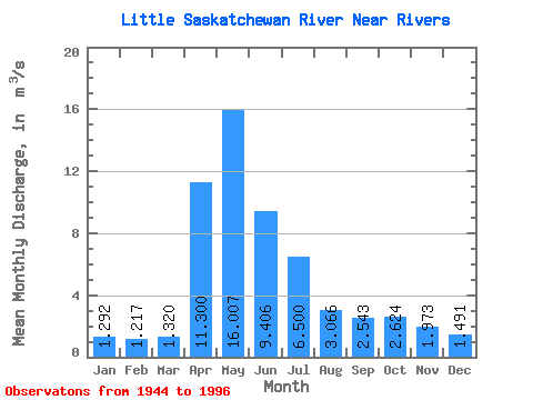
| Mean | 1.29 | 1.22 | 1.32 | 11.30 | 16.01 | 9.41 | 6.50 | 3.07 | 2.54 | 2.62 | 1.97 | 1.49 | 4.54 |
| Standard Deviation | 0.87 | 0.79 | 1.17 | 9.90 | 12.88 | 8.55 | 8.17 | 3.03 | 3.69 | 3.50 | 1.84 | 1.06 | 3.03 |
| Min | 0.01 | 0.00 | 0.03 | 0.19 | 0.14 | 0.59 | 0.48 | 0.23 | 0.02 | 0.01 | 0.03 | 0.17 | 0.39 |
| Max | 4.04 | 3.60 | 7.05 | 47.80 | 55.00 | 43.70 | 43.20 | 13.40 | 23.80 | 23.20 | 8.80 | 4.35 | 14.00 |
| Coefficient of Variation | 0.68 | 0.65 | 0.89 | 0.88 | 0.81 | 0.91 | 1.26 | 0.99 | 1.45 | 1.33 | 0.93 | 0.71 | 0.67 |
 Return to R-Arctic Net Home Page