|
|
|||||||||||||||||
| Point ID: 2850 | Downloads | Plots | Site Data | Code: 05LL002 |
|
|
|||||||||||||||||
| Download | |
|---|---|
| Site Descriptor Information | Site Time Series Data |
| Link to all available data | |
| View: | Time Series | All |
| Units: | m3/s |
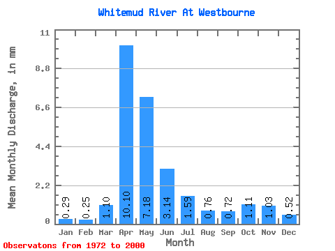
| Statistic | Jan | Feb | Mar | Apr | May | Jun | Jul | Aug | Sep | Oct | Nov | Dec | Annual |
|---|---|---|---|---|---|---|---|---|---|---|---|---|---|
| Mean | 0.29 | 0.25 | 1.10 | 10.10 | 7.18 | 3.14 | 1.59 | 0.76 | 0.72 | 1.11 | 1.03 | 0.52 | 28.10 |
| Standard Deviation | 0.25 | 0.18 | 1.03 | 9.93 | 8.42 | 2.99 | 1.35 | 0.62 | 1.10 | 1.02 | 1.10 | 0.42 | 21.15 |
| Min | 0.07 | 0.05 | 0.10 | 1.89 | 0.83 | 0.39 | 0.27 | 0.06 | 0.07 | 0.15 | 0.23 | 0.09 | 5.67 |
| Max | 1.41 | 0.91 | 3.98 | 45.50 | 39.20 | 12.92 | 5.12 | 2.06 | 5.85 | 5.88 | 4.88 | 2.08 | 83.13 |
| Coefficient of Variation | 0.86 | 0.72 | 0.94 | 0.98 | 1.17 | 0.95 | 0.85 | 0.81 | 1.53 | 0.92 | 1.06 | 0.82 | 0.75 |
 Return to R-Arctic Net Home Page