|
|
|||||||||||||||||
| Point ID: 2850 | Downloads | Plots | Site Data | Code: 05LL002 |
|
|
|||||||||||||||||
| Download | |
|---|---|
| Site Descriptor Information | Site Time Series Data |
| Link to all available data | |
| View: | Time Series | All |
| Units: | mm |
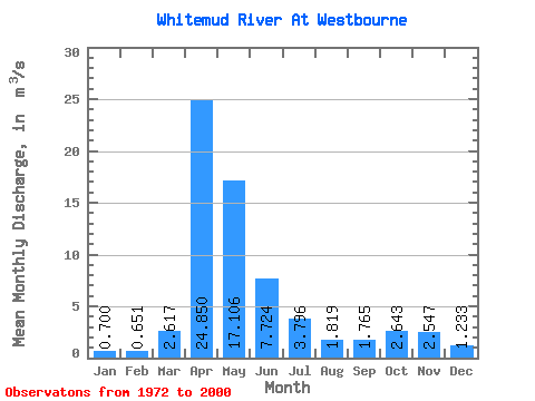
| Statistic | Jan | Feb | Mar | Apr | May | Jun | Jul | Aug | Sep | Oct | Nov | Dec | Annual |
|---|---|---|---|---|---|---|---|---|---|---|---|---|---|
| Mean | 0.70 | 0.65 | 2.62 | 24.85 | 17.11 | 7.72 | 3.80 | 1.82 | 1.77 | 2.64 | 2.55 | 1.23 | 5.68 |
| Standard Deviation | 0.60 | 0.47 | 2.46 | 24.45 | 20.06 | 7.35 | 3.21 | 1.47 | 2.70 | 2.44 | 2.70 | 1.01 | 4.28 |
| Min | 0.17 | 0.13 | 0.24 | 4.66 | 1.99 | 0.95 | 0.63 | 0.15 | 0.16 | 0.35 | 0.56 | 0.21 | 1.15 |
| Max | 3.35 | 2.39 | 9.47 | 112.00 | 93.40 | 31.80 | 12.20 | 4.91 | 14.40 | 14.00 | 12.00 | 4.95 | 16.80 |
| Coefficient of Variation | 0.86 | 0.72 | 0.94 | 0.98 | 1.17 | 0.95 | 0.85 | 0.81 | 1.53 | 0.92 | 1.06 | 0.82 | 0.75 |
 Return to R-Arctic Net Home Page