|
|
|||||||||||||||||
| Point ID: 2830 | Downloads | Plots | Site Data | Code: 05LJ020 |
|
|
|||||||||||||||||
| Download | |
|---|---|
| Site Descriptor Information | Site Time Series Data |
| Link to all available data | |
| View: | Time Series | All |
| Units: | m3/s |
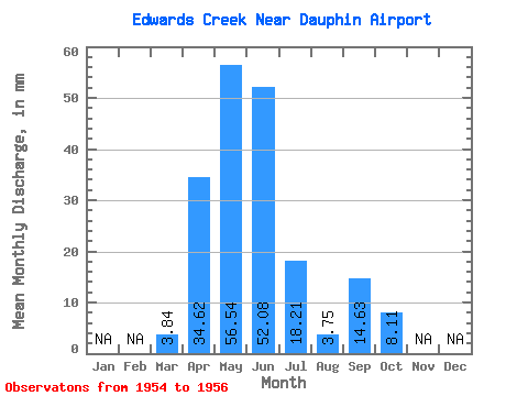
| Statistic | Jan | Feb | Mar | Apr | May | Jun | Jul | Aug | Sep | Oct | Nov | Dec | Annual |
|---|---|---|---|---|---|---|---|---|---|---|---|---|---|
| Mean | 3.84 | 34.62 | 56.54 | 52.09 | 18.21 | 3.74 | 14.63 | 8.11 | |||||
| Standard Deviation | 12.44 | 17.44 | 4.61 | 11.73 | 1.57 | 22.03 | 10.65 | ||||||
| Min | 3.84 | 25.73 | 38.23 | 47.33 | 6.42 | 1.92 | 0.39 | 1.20 | |||||
| Max | 3.84 | 48.84 | 72.97 | 56.54 | 29.89 | 4.66 | 40.01 | 20.38 | |||||
| Coefficient of Variation | 0.36 | 0.31 | 0.09 | 0.64 | 0.42 | 1.51 | 1.31 |
 Return to R-Arctic Net Home Page