|
|
| Point ID: 2830 | Downloads | Plots | Site Data | Code: 05LJ020 |
|
| Download | |
|---|---|
| Site Descriptor Information | Site Time Series Data |
| Link to all available data | |
|
|
|
| View: | Statistics | All |
| Units: | m3/s |
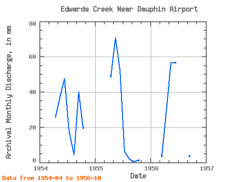
| Year | Jan | Feb | Mar | Apr | May | Jun | Jul | Aug | Sep | Oct | Nov | Dec | Annual | 1954 | 25.73 | 38.23 | 47.33 | 18.32 | 4.64 | 40.01 | 20.38 | 1955 | 48.84 | 72.97 | 52.40 | 6.42 | 1.92 | 0.39 | 1.20 | 1956 | 3.84 | 29.30 | 58.41 | 56.54 | 29.89 | 4.66 | 3.49 | 2.76 |
|---|
 Return to R-Arctic Net Home Page