|
|
|||||||||||||||||
| Point ID: 2770 | Downloads | Plots | Site Data | Code: 10BE011 |
|
|
|||||||||||||||||
| Download | |
|---|---|
| Site Descriptor Information | Site Time Series Data |
| Link to all available data | |
| View: | Time Series | All |
| Units: | m3/s |
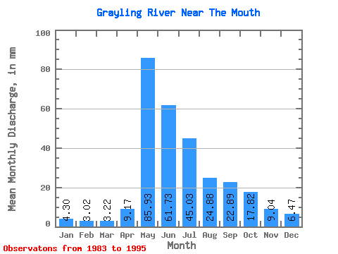
| Statistic | Jan | Feb | Mar | Apr | May | Jun | Jul | Aug | Sep | Oct | Nov | Dec | Annual |
|---|---|---|---|---|---|---|---|---|---|---|---|---|---|
| Mean | 4.30 | 3.05 | 3.22 | 9.17 | 85.92 | 61.73 | 45.02 | 24.88 | 22.89 | 17.82 | 9.04 | 6.47 | 291.60 |
| Standard Deviation | 1.41 | 0.97 | 0.80 | 5.58 | 37.60 | 26.48 | 32.05 | 12.38 | 12.22 | 9.69 | 3.90 | 2.45 | 68.13 |
| Min | 2.02 | 1.31 | 1.77 | 3.16 | 42.73 | 26.21 | 16.25 | 12.53 | 8.04 | 7.60 | 4.64 | 3.23 | 173.28 |
| Max | 7.00 | 4.83 | 4.81 | 20.97 | 185.05 | 111.11 | 113.14 | 48.14 | 46.74 | 38.97 | 15.87 | 11.68 | 372.75 |
| Coefficient of Variation | 0.33 | 0.32 | 0.25 | 0.61 | 0.44 | 0.43 | 0.71 | 0.50 | 0.53 | 0.54 | 0.43 | 0.38 | 0.23 |
 Return to R-Arctic Net Home Page