|
|
|||||||||||||||||
| Point ID: 2770 | Downloads | Plots | Site Data | Code: 10BE011 |
|
|
|||||||||||||||||
| Download | |
|---|---|
| Site Descriptor Information | Site Time Series Data |
| Link to all available data | |
| View: | Time Series | All |
| Units: | mm |
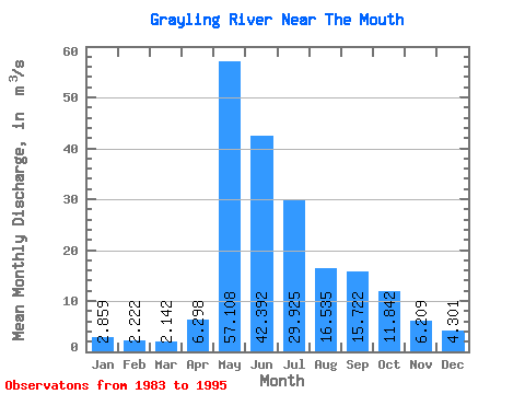
| Statistic | Jan | Feb | Mar | Apr | May | Jun | Jul | Aug | Sep | Oct | Nov | Dec | Annual |
|---|---|---|---|---|---|---|---|---|---|---|---|---|---|
| Mean | 2.86 | 2.22 | 2.14 | 6.30 | 57.11 | 42.39 | 29.93 | 16.54 | 15.72 | 11.84 | 6.21 | 4.30 | 16.45 |
| Standard Deviation | 0.94 | 0.71 | 0.53 | 3.83 | 24.99 | 18.18 | 21.30 | 8.23 | 8.39 | 6.44 | 2.68 | 1.63 | 3.84 |
| Min | 1.34 | 0.96 | 1.18 | 2.17 | 28.40 | 18.00 | 10.80 | 8.33 | 5.52 | 5.05 | 3.19 | 2.15 | 9.77 |
| Max | 4.65 | 3.52 | 3.20 | 14.40 | 123.00 | 76.30 | 75.20 | 32.00 | 32.10 | 25.90 | 10.90 | 7.76 | 21.02 |
| Coefficient of Variation | 0.33 | 0.32 | 0.25 | 0.61 | 0.44 | 0.43 | 0.71 | 0.50 | 0.53 | 0.54 | 0.43 | 0.38 | 0.23 |
 Return to R-Arctic Net Home Page