|
|
|||||||||||||||||
| Point ID: 2763 | Downloads | Plots | Site Data | Code: 10BE004 |
|
|
|||||||||||||||||
| Download | |
|---|---|
| Site Descriptor Information | Site Time Series Data |
| Link to all available data | |
| View: | Time Series | All |
| Units: | m3/s |
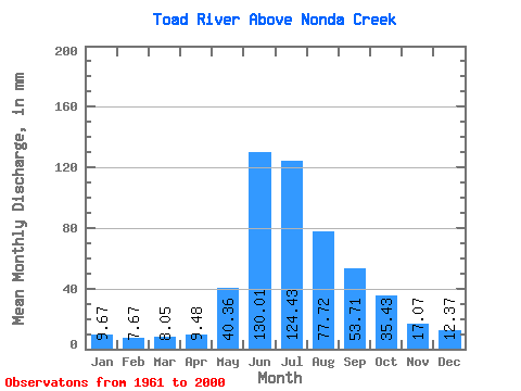
| Statistic | Jan | Feb | Mar | Apr | May | Jun | Jul | Aug | Sep | Oct | Nov | Dec | Annual |
|---|---|---|---|---|---|---|---|---|---|---|---|---|---|
| Mean | 9.67 | 7.74 | 8.05 | 9.48 | 40.35 | 130.01 | 124.41 | 77.71 | 53.71 | 35.43 | 17.07 | 12.37 | 529.08 |
| Standard Deviation | 1.86 | 1.40 | 1.44 | 1.68 | 18.15 | 28.10 | 40.03 | 21.55 | 16.47 | 11.15 | 3.69 | 2.24 | 81.29 |
| Min | 5.29 | 3.53 | 3.68 | 6.57 | 15.32 | 72.52 | 62.10 | 46.06 | 29.55 | 18.96 | 10.69 | 7.72 | 367.33 |
| Max | 14.17 | 12.06 | 12.40 | 13.21 | 106.29 | 191.63 | 212.57 | 140.67 | 105.90 | 65.96 | 26.32 | 17.71 | 742.46 |
| Coefficient of Variation | 0.19 | 0.18 | 0.18 | 0.18 | 0.45 | 0.22 | 0.32 | 0.28 | 0.31 | 0.32 | 0.22 | 0.18 | 0.15 |
 Return to R-Arctic Net Home Page