|
|
|||||||||||||||||
| Point ID: 2763 | Downloads | Plots | Site Data | Code: 10BE004 |
|
|
|||||||||||||||||
| Download | |
|---|---|
| Site Descriptor Information | Site Time Series Data |
| Link to all available data | |
| View: | Time Series | All |
| Units: | mm |
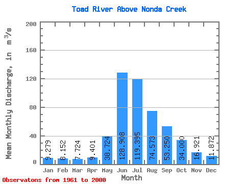
| Statistic | Jan | Feb | Mar | Apr | May | Jun | Jul | Aug | Sep | Oct | Nov | Dec | Annual |
|---|---|---|---|---|---|---|---|---|---|---|---|---|---|
| Mean | 9.28 | 8.15 | 7.72 | 9.40 | 38.72 | 128.91 | 119.39 | 74.57 | 53.25 | 34.00 | 16.92 | 11.87 | 43.09 |
| Standard Deviation | 1.79 | 1.48 | 1.38 | 1.67 | 17.42 | 27.86 | 38.41 | 20.68 | 16.33 | 10.70 | 3.66 | 2.15 | 6.62 |
| Min | 5.08 | 3.72 | 3.53 | 6.51 | 14.70 | 71.90 | 59.60 | 44.20 | 29.30 | 18.20 | 10.60 | 7.41 | 29.91 |
| Max | 13.60 | 12.70 | 11.90 | 13.10 | 102.00 | 190.00 | 204.00 | 135.00 | 105.00 | 63.30 | 26.10 | 17.00 | 60.46 |
| Coefficient of Variation | 0.19 | 0.18 | 0.18 | 0.18 | 0.45 | 0.22 | 0.32 | 0.28 | 0.31 | 0.32 | 0.22 | 0.18 | 0.15 |
 Return to R-Arctic Net Home Page