|
|
|||||||||||||||||
| Point ID: 2760 | Downloads | Plots | Site Data | Code: 10BC001 |
|
|
|||||||||||||||||
| Download | |
|---|---|
| Site Descriptor Information | Site Time Series Data |
| Link to all available data | |
| View: | Time Series | All |
| Units: | m3/s |
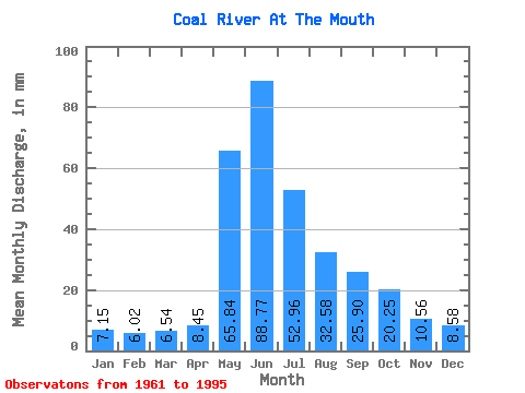
| Statistic | Jan | Feb | Mar | Apr | May | Jun | Jul | Aug | Sep | Oct | Nov | Dec | Annual |
|---|---|---|---|---|---|---|---|---|---|---|---|---|---|
| Mean | 7.15 | 6.07 | 6.54 | 8.45 | 65.83 | 88.77 | 52.95 | 32.58 | 25.90 | 20.25 | 10.56 | 8.58 | 334.96 |
| Standard Deviation | 1.31 | 1.08 | 1.20 | 2.34 | 17.10 | 26.13 | 20.33 | 10.99 | 8.42 | 5.28 | 3.23 | 1.82 | 64.57 |
| Min | 4.78 | 3.61 | 3.99 | 5.08 | 22.93 | 40.90 | 27.36 | 17.45 | 15.29 | 11.89 | 5.58 | 5.77 | 227.77 |
| Max | 10.23 | 8.42 | 9.00 | 13.17 | 98.79 | 145.82 | 103.45 | 60.90 | 56.41 | 32.35 | 17.85 | 12.12 | 444.15 |
| Coefficient of Variation | 0.18 | 0.18 | 0.18 | 0.28 | 0.26 | 0.29 | 0.38 | 0.34 | 0.33 | 0.26 | 0.30 | 0.21 | 0.19 |
 Return to R-Arctic Net Home Page