|
|
|||||||||||||||||
| Point ID: 2760 | Downloads | Plots | Site Data | Code: 10BC001 |
|
|
|||||||||||||||||
| Download | |
|---|---|
| Site Descriptor Information | Site Time Series Data |
| Link to all available data | |
| View: | Time Series | All |
| Units: | mm |
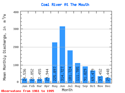
| Statistic | Jan | Feb | Mar | Apr | May | Jun | Jul | Aug | Sep | Oct | Nov | Dec | Annual |
|---|---|---|---|---|---|---|---|---|---|---|---|---|---|
| Mean | 24.54 | 22.85 | 22.45 | 29.94 | 225.90 | 314.73 | 181.72 | 111.78 | 91.83 | 69.48 | 37.45 | 29.45 | 97.54 |
| Standard Deviation | 4.51 | 4.08 | 4.12 | 8.31 | 58.69 | 92.65 | 69.77 | 37.73 | 29.86 | 18.13 | 11.44 | 6.26 | 18.80 |
| Min | 16.40 | 13.60 | 13.70 | 18.00 | 78.70 | 145.00 | 93.90 | 59.90 | 54.20 | 40.80 | 19.80 | 19.80 | 66.33 |
| Max | 35.10 | 31.70 | 30.90 | 46.70 | 339.00 | 517.00 | 355.00 | 209.00 | 200.00 | 111.00 | 63.30 | 41.60 | 129.33 |
| Coefficient of Variation | 0.18 | 0.18 | 0.18 | 0.28 | 0.26 | 0.29 | 0.38 | 0.34 | 0.33 | 0.26 | 0.30 | 0.21 | 0.19 |
 Return to R-Arctic Net Home Page