|
|
|||||||||||||||||
| Point ID: 2756 | Downloads | Plots | Site Data | Code: 10AD001 |
|
|
|||||||||||||||||
| Download | |
|---|---|
| Site Descriptor Information | Site Time Series Data |
| Link to all available data | |
| View: | Time Series | All |
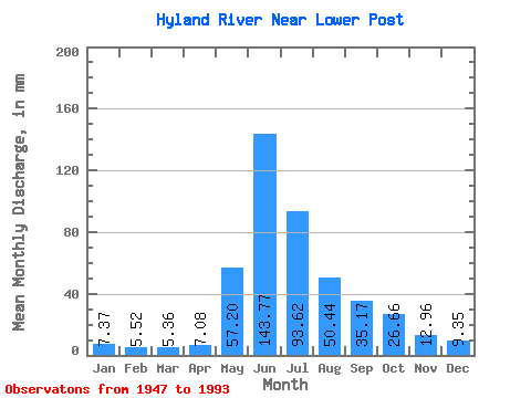
| Units: | m3/s |
| Statistic | Jan | Feb | Mar | Apr | May | Jun | Jul | Aug | Sep | Oct | Nov | Dec | Annual |
|---|---|---|---|---|---|---|---|---|---|---|---|---|---|
| Mean | 7.37 | 5.57 | 5.36 | 7.08 | 57.19 | 143.77 | 93.61 | 50.43 | 35.17 | 26.66 | 12.96 | 9.35 | 454.94 |
| Standard Deviation | 1.60 | 1.28 | 1.22 | 3.21 | 21.44 | 34.76 | 29.82 | 13.53 | 8.41 | 7.81 | 3.82 | 2.23 | 79.98 |
| Min | 4.73 | 3.43 | 2.54 | 4.47 | 24.40 | 72.41 | 43.36 | 29.76 | 19.20 | 13.32 | 4.75 | 5.50 | 285.46 |
| Max | 11.22 | 8.47 | 8.02 | 22.25 | 123.84 | 246.31 | 174.00 | 84.17 | 61.71 | 45.06 | 20.98 | 13.04 | 679.93 |
| Coefficient of Variation | 0.22 | 0.23 | 0.23 | 0.45 | 0.38 | 0.24 | 0.32 | 0.27 | 0.24 | 0.29 | 0.29 | 0.24 | 0.18 |
 Return to R-Arctic Net Home Page