|
|
|||||||||||||||||
| Point ID: 2756 | Downloads | Plots | Site Data | Code: 10AD001 |
|
|
|||||||||||||||||
| Download | |
|---|---|
| Site Descriptor Information | Site Time Series Data |
| Link to all available data | |
| View: | Time Series | All |
| Units: | mm |
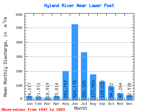
| Statistic | Jan | Feb | Mar | Apr | May | Jun | Jul | Aug | Sep | Oct | Nov | Dec | Annual |
|---|---|---|---|---|---|---|---|---|---|---|---|---|---|
| Mean | 26.02 | 21.57 | 18.92 | 25.81 | 201.80 | 524.17 | 330.32 | 177.95 | 128.23 | 94.07 | 47.26 | 32.98 | 136.22 |
| Standard Deviation | 5.66 | 4.96 | 4.30 | 11.70 | 75.66 | 126.71 | 105.25 | 47.74 | 30.66 | 27.57 | 13.91 | 7.87 | 23.95 |
| Min | 16.70 | 13.30 | 8.96 | 16.30 | 86.10 | 264.00 | 153.00 | 105.00 | 70.00 | 47.00 | 17.30 | 19.40 | 85.47 |
| Max | 39.60 | 32.80 | 28.30 | 81.10 | 437.00 | 898.00 | 614.00 | 297.00 | 225.00 | 159.00 | 76.50 | 46.00 | 203.59 |
| Coefficient of Variation | 0.22 | 0.23 | 0.23 | 0.45 | 0.38 | 0.24 | 0.32 | 0.27 | 0.24 | 0.29 | 0.29 | 0.24 | 0.18 |
 Return to R-Arctic Net Home Page