|
|
|||||||||||||||||
| Point ID: 2754 | Downloads | Plots | Site Data | Code: 10AC005 |
|
|
|||||||||||||||||
| Download | |
|---|---|
| Site Descriptor Information | Site Time Series Data |
| Link to all available data | |
| View: | Time Series | All |
| Units: | m3/s |
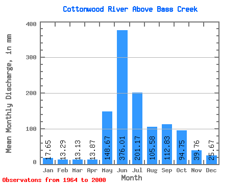
| Statistic | Jan | Feb | Mar | Apr | May | Jun | Jul | Aug | Sep | Oct | Nov | Dec | Annual |
|---|---|---|---|---|---|---|---|---|---|---|---|---|---|
| Mean | 9.84 | 7.47 | 7.32 | 7.73 | 82.86 | 209.60 | 112.12 | 58.85 | 62.90 | 52.81 | 22.17 | 14.31 | 646.92 |
| Standard Deviation | 1.78 | 1.60 | 1.48 | 2.17 | 40.54 | 49.52 | 41.50 | 20.93 | 25.99 | 22.48 | 5.42 | 2.24 | 96.69 |
| Min | 6.15 | 3.44 | 4.98 | 3.82 | 32.87 | 83.77 | 39.20 | 29.22 | 26.18 | 21.93 | 13.92 | 7.93 | 420.27 |
| Max | 14.11 | 11.76 | 11.19 | 12.32 | 227.69 | 309.40 | 215.33 | 110.68 | 125.81 | 137.22 | 36.49 | 20.36 | 837.57 |
| Coefficient of Variation | 0.18 | 0.21 | 0.20 | 0.28 | 0.49 | 0.24 | 0.37 | 0.36 | 0.41 | 0.43 | 0.24 | 0.16 | 0.15 |
 Return to R-Arctic Net Home Page